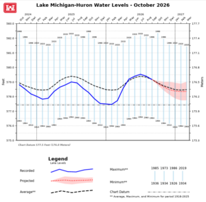
Lake Michigan-Huron is currently 7 inches higher than at this time last year, though seasonal declines are underway across all the Great Lakes.
Month-over-Month & Year-over-Year Comparisons
Compared to Last Month:
-
- Lake Superior: Down 3″
- Lake Michigan-Huron: Down 4″
- Lake St. Clair: Down 5″
- Lake Erie: Down 4″
- Lake Ontario: Down 8″
Compared to Last Year:
-
- Lake Superior: Down 2″
- Lake Michigan-Huron: Up 7″
- Lake St. Clair: Up 5″
- Lake Erie: Up 5″
- Lake Ontario: Up 9″
Long-Term October Averages: Lake Superior sits 6″ below its historic October average, while Michigan-Huron is 3″ below. Lake St. Clair (+3″), Erie (+4″), and Ontario (+5″) remain above their long-term averages. However, water levels across all the lakes remain well below historic record highs.
One-Month Forecast: Water levels are expected to decline across all the Great Lakes over the coming month: Lake Superior (-2″), Lake Michigan-Huron (-2″), St. Clair (-5″), Erie (-3″), and Ontario (-2″).

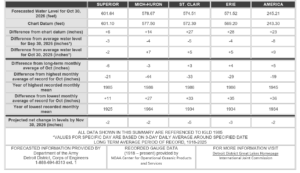
Lake Superior’s outflow through the St. Marys River and Lake St. Clair’s outflow through the Detroit River are projected to be near average for October. Lake Michigan-Huron’s outflow through the St. Clair River, Lake Erie’s outflow through the Niagara River, and Lake Ontario’s outflow through the St. Lawrence River are projected to be above average in October.
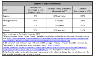
This report below shows the most recent month of precipitation and outflows published by Level News:
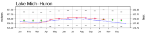
With regard to the forecast graph below (and the more recently updated first graph in this report), the USACE predicts that Lake Michigan-Huron levels will likely drop from August through January.
Monthly mean water levels for the previous year and the current year to date are shown as a solid line on the hydrographs. A projection for the next six months is given as a dashed line. This projection is based on the present condition of the lake basin and anticipated future weather. The shaded area shows a range of possible levels over the next six months dependent upon weather variations. Current and projected levels (solid and dashed lines) can be compared with the 1918-2021 average levels (dotted line) and extreme levels (shown as bars with their year of occurrence). The legend below further identifies the information on the hydrographs.