GBGLF January 2018 meets with Canadian Section IJC Chair Walker and staff
On January 24, Mary Muter, Chair of the Georgian Bay Great Lakes Foundation’ arranged a meeting with the International Joint Commission (IJC) in Ottawa, so I could present the latest results of hydraulic modeling work on the St. Clair River and the potential impacts on the water levels of Lakes Michigan-Huron (MH).
Present were Commissioner Gordon Walker, the Chair of the IJC Canadian Section, Commissioner Benoit Bouchard, and David Fay, Senior Engineering Advisor to the IJC Canadian Section, and by video link with Washington, D.C. Dr. Mark Colosimo, the IJC US Section Engineering Advisor. David Fay had enabled my hydraulic modeling work to start in 2009. At this meeting, I reported on the engineering feasibility of the IJC’s 2013 advise to governments.
Background History
 But first a quick refresher. Recall that since 1850, navigation dredging and gravel mining, expanded the St. Clair flow capacity year-by-year until 1962, when the last dredging project was completed and the Seaway opened. By 1962, this expanded capacity had lowered the level of Lakes MH by 40 cm (16 inches) based on IJC records. The IJC’s mandate is to advise the American and Canadian governments on how to restore water levels on Lakes MH after dredging has lowered them. By 1970 this work had been completed right along the Seaway, except for Lakes MH. Finally, in 1970 the US Army Corps was tasked to design the hydraulic compensation works for the St. Clair River to restore Lakes MH lost level – sills or speed bumps were to be located along the river bottom near the Blue Water Bridge. In 1977, just as work was starting, water supplies rose sharply causing water levels to rise until they reached an all-time high in 1986. The project was abandoned.
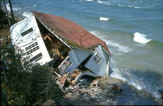
Enormous damage resulted from the 1986 high water. Along the southern shores of Lake Michigan, houses built on high bluffs toppled into the water after storms eroded the bluffs below. A politically powerful group formed to oppose any structures in the St. Clair River and threatened that any such proposal would face fierce litigation.The US Army Corps sills were designed to raise water regardless of low or high water.
Baird Report and resulting IJC’s International Upper Great Lakes Study Outcomes
The 1962 dredging triggered ongoing erosion of the St. Clair River bottom, which further lowered Lake MH by a total of 50 cm (20 inches) based on IJC records. This erosion was finally uncovered by the Baird Report of 2005, which was initiated by Mary Muter, then GBA Vice President. The International Upper Great Lakes Study (IUGLS) of 2007, was tasked to prove or disprove this Baird – alleged erosion and Lake MH lowering. The study was led by a US Army Corps official, and concluded that the erosion in the St. Clair River and the lowering of the water level of MH lowering did in fact occur, but far less than claimed by Baird. Nevertheless, the study recommended that NOTHING BE DONE in the St. Clair. Could the threat of litigation trump science?
In 2009 I attended the IJC public hearing in Midland, where the DO-NOTHING recommendation was announced. Having retired from an engineering career dominated by mathematical modeling, I stood up and questioned the accuracy of this result and asked “Would the study board allow an independent assessment of this result? Could the study board provide the discharge equations for the St. Clair, Detroit and Niagara rivers, along with water levels and flow data?” To my surprise the answer was yes. David Fay provided me with the needed hydraulic equations for the rivers. He then was the Canadian member and chief hydraulics engineer on the bi-national Coordinating Committee on Great Lakes Basin Hydraulic and Hydrologic Data.
I created a working hydraulic model of water levels and flows from Lake Superior to Lake Ontario. The trickiest part was accounting for the expanded flow capacity of the St. Clair River between 1900 and the present. With this challenge conquered, the model was able to closely duplicate actual data for each month for over 100 years. The model was then expanded so that downstream impacts all the way to Montreal could be considered. It became apparent that using fixed structures to restore low water on Lake MH could only be done at the expense of exacerbating high water when this occurs. To simultaneously address both extremely low-water and high-water levels, some form of flexible structure was needed that could be turned on and off. Power turbines appeared to be most attractive. However, in 2010, a research report identified that as long as a shipping channel remained in use, turbines would hardly raise water levels or generate much electricity, as most of the water would simply flow through this open and wide channel. Many ideas were tried and reported to the IJC.
Finding a viable solution
A control design strategy to effectively deploy flexible structures as water levels naturally fluctuated between high and low levels appeared to be a far greater challenge than that of the workable flexible structure itself. Fortunately, the IJC’s 1993 Level Reference study laid the foundation for this concept in their Annex 6 – “Crisis response measures”. The simple use of the then established Crisis high and low levels that the IJC defined for each of the Great Lakes appeared to provide the promise of a working model. Deploying the flexible structures to slow the water only as long as the MH level remained below the “Low Action Level” of 176.8m above sea level, appeared to be a promising start. Then, as soon as the level exceeded 176.8m, the structures would be lowered to a very low drag position to prevent high water levels from rising further. My January 24 presentation to the IJC demonstrated that this was in fact a feasible control strategy.
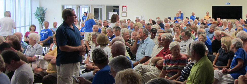
Back now to 2012: the IJC still accepted the IUGLS “Do-Nothing” recommendation – until the moment came when they changed their mind. I was at the final IJC public hearing in Midland on July 16, 2012 when this happened; crammed into the IJC meeting room were well over 600 people, many wearing blue “Restore our Water Levels” T-Shirts.

After many impassioned presentations and heated arguments, the Canadian IJC Commissioner, Lyall Knott, declared over the PA System: “We hear you loud and clear: Restore our Water Levels, Restore Our Water Levels NOW”. It took another year, but on April 15, 2013, the IJC’s Advice to governments was delivered, and includes two key statements:
“The Commission recommends that the Governments undertake further investigation of structural options to restore water levels in Lake Michigan-Huron.
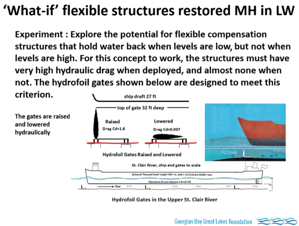
The first statement finally reverses the IUGLS “Do-Nothing” recommendation. The second statement recommends some form of flexible structure that can raise the level during low water, and can be turned off during high water. Below is the slide from my January 24 presentation which speaks to this concept.
Will hydrofoil gates work? And could both US and Canadian stakeholders support them?
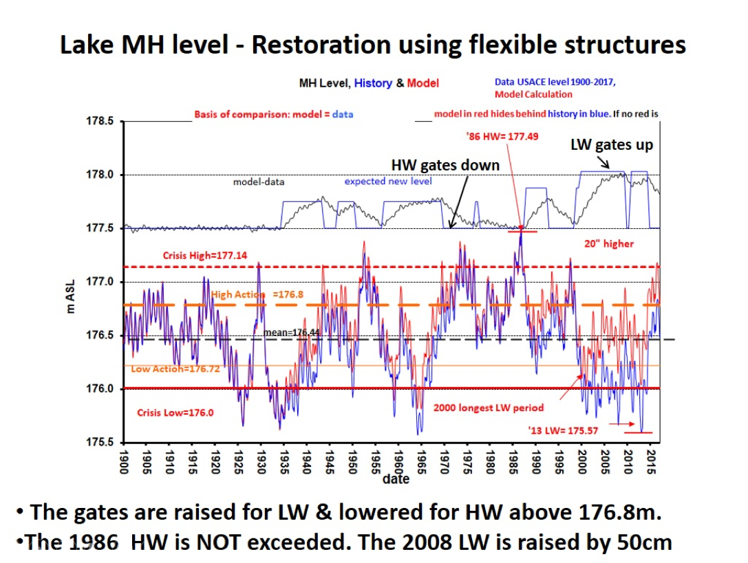
The following image confirms that the IJC’s 2013 “Advice to Governments” is feasible. Illustrated is the actual sequence of high and low water levels on Lake MH from 1935 to 2017. In 1935 the dredging of the 25-foot channel began. In the model, flexible ‘hydrofoil gates’ are deployed in the St. Clair River above the Blue Water Bridge in 1935. More are added in 1962 for the Seaway dredging, and still more in 2000, to account for the erosion. By 2000 there are enough gates in the river to raise the water level by 50 cm when all are raised.
The blue graph shows the historical monthly water levels as recoded by the US Army Corps of Engineers. The red graph shows water levels predicted by the model with the hydrofoil gates in place. The gates are raised to their vertical position to slow the water when the water level is below the “High Action limit of 176.8m” – the bold dashed orange line. When the water level exceeds 176.8m, the gates are lowered to the ‘down’ position, to provide minimum flow resistance. There are two critical time periods of interest:
The thin black line is the difference between the model and data, and clearly shows how the water level changes dynamically. The thin blue line represents the expected final level. It is a useful indication of when the gates are in the Up or Down position.

Canadian Section IJC Support
In conclusion, the IJC was presented with this proof that the concept at the heart of its advice to governments can in fact work. A range of other options for lowering excessive high water by using diversions and ice booms was also evaluated.
We have just received a response from Gordon Walker that in part says:
“Mary, thanks for providing the assessment on options for restoring Lake Michigan-Huron levels. … I think it will be invaluable for the ultimate assessment that will need to be done by … probably the Corps of Engineers. However, that is a long way off.
We now have an accumulated dossier on the question of ‘compensating works’ in the River St. Clair and their impact, and what might be achieved by the various options. Your extensive submission, as created by Bill Bialkowski, will further that debate immensely. So, thank you for that.
The real issue right now is getting the US Government …. to ‘weigh in ‘on this topic.
Thanks again Mary and Bill for making the trek to Ottawa to give us the presentation.
Regards.
Gordon W. Walker, Q.C.
Chair, Canadian Section, International Joint Commission”
Currently, then, our Georgian Bay Great Lakes Foundation as a member organization of Restore Our Water International, is challenged to bring all Great Lakes stakeholders and especially the US government onside with the above proposal. United action will finally right a wrong created over the last century and half by installing in the upper St. Clair River flexible structures which, facing climate change, will protect all interests around all the lakes. The voiceless interest – the most important one – is the wildlife, which depends on the wetlands.
By Bill Bialkowski
Bill is on the GBGLF board (http://www.georgianbaygreatlakesfoundation.com/) donations to the work of bringing US stakeholders on side would be appreciated.
Download this story and the entire WCA Spring Newsletter May 2018 in PDF format (1.5MB).